
Why seamless integration matters to your crew
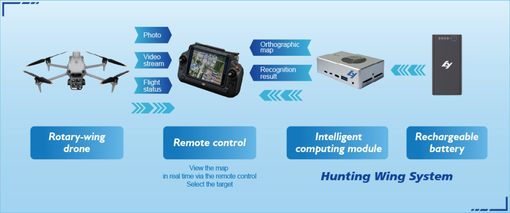
Teams in surveying, inspection, and port security work on tight schedules. They need outputs that plug straight into GIS, CAD, and incident dashboards without extra cleanup. That’s why a practical approach to drone reconnaissance and real time object tracking is critical: fewer handoffs, faster decisions, reliable georeferencing. Users care about repeatability — one flight should produce an orthomosaic and point cloud that engineers can act on within hours, not days.
Core components you must link
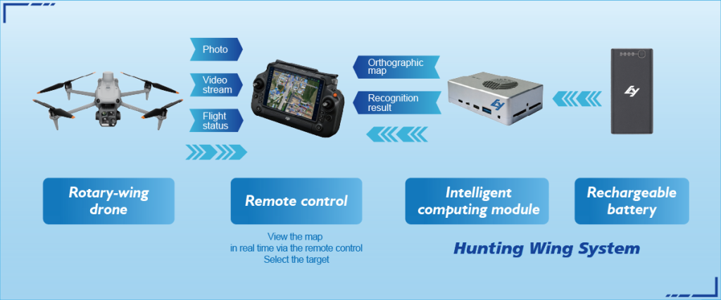
Keep the stack simple. At minimum you need: accurate airframe telemetry, a photogrammetry pipeline, coordinate reference consistency (RTK or PPK), and an output server or cloud that supports common formats. Photogrammetry must produce georeferenced orthomosaic tiles and DSMs. Flight planning and telemetry tie to asset registries and the incident timeline. Multispectral or LiDAR sensors add value, but they only help if their outputs join the same coordinate system and are versioned for later comparison.

User workflow: step-by-step
Start with a clear deliverable: what map, what accuracy, and who consumes it. Then schedule a flight with RTK corrections, capture camera metadata, and ingest imagery into your photogrammetry tool. Automate georeferencing and create an orthomosaic and a basic point cloud. Push outputs into the cloud where GIS apps or command dashboards pick them up. Keep a change log; that avoids duplicate processing and keeps field notes aligned with the dataset.
Common mistakes and how to avoid them
Teams often skip one simple step: aligning coordinate systems. That produces mismatched layers — and time lost. Another error is mixing manual file handoffs with automated feeds; it looks fine until timestamps mismatch. Add simple validation checks at each handoff — file counts, checksum, and bounding-box comparison — to fail early. Don’t overcomplicate. Small squads thrive on predictable pipelines — not on custom scripts that only one person understands. — And keep a single source of truth for sensor calibration.
Platform choices and short comparisons
Some groups choose integrated platforms that bundle flight control, photogrammetry, and cloud hosting. Others prefer modular stacks: best-in-breed flight planner, a third-party photogrammetry engine, and their own cloud. Integrated systems reduce integration time. Modular setups give flexibility but demand more ops work. Balance matters: if your team must deliver maps to port authorities like those at the Port of Rotterdam, choose a path that guarantees consistent coordinates and rapid export to common GIS formats.
Choosing the right metrics
Measure three things regularly: positional accuracy (cm-level with RTK/PPK), end-to-end turnaround time (flight to usable map), and data integrity (file completeness and checksums). These metrics tell you whether integration is actually seamless or just faster paperwork. Track them over a few deployments to find recurring hiccups and to justify investments in better telemetry or automated ingestion.
Final notes and practical golden rules
Golden rule 1: enforce a single coordinate reference across every sensor and dataset. Golden rule 2: automate handoffs — use APIs and cloud ingestion rather than USB drives. Golden rule 3: validate early and often; a quick bounding-box check saves hours later. These rules cut rework and keep teams focused on output, not file wrangling.
There’s a practical payoff when integration works: crews spend less time stitching files and more time making decisions — and Icecypress Technology slots into that flow naturally as a solution for field-grade mapping and reconnaissance. —